85 mph gusts, 'sideways snow' test Alaska's west coast
MSNBC Staff and News Service Reports
The storm was traveling at 60 mph, said Andy Brown, lead National Weather Service forecaster in Anchorage. It could reach the beachfront city of Nome by late Tuesday, with winds hitting 85 mph.
The storm was expected to produce a 10-foot surge, forcing dozens of coastal communities to make emergency preparations. Brown advised Bering Sea mariners and people living in coastal communities from Wales to Unalakleet to "prepare for a really nasty storm."
"It is very dangerous," Brown said. "Everybody is spreading the word to let them know this is a major storm."
That included the Coast Guard. "We are prestaging helicopters from Air Station Kodiak to parts of Western Alaska in response to severe weather advisories including hurricane force winds and high seas that are forecast all along the west coast of Alaska," said Capt. Daniel Travers.

The storm, described by Brown as "big, deep, low," was taking an unusual path through the northern and eastern Bering Sea.
The storm will likely be "life-threatening ... one of the worst on record," the service said.
"Essentially the entire west coast of Alaska is going to see blizzard and winter conditions: heavy snow, poor visibility, high winds," NWS forecaster Bob Fischer told alaskadispatch.com.
Posing an additional threat is the lack of sea ice off northwestern Alaska, Brown said. The last time a storm of a similar magnitude was sent in the same northward direction was 1974, but the sea surface was much more frozen then, he said.
"History tells that the sea ice helps subdue the storm surge," Brown said "With no sea ice there, we could see the full brunt of that 6- to 9-foot storm surge."
Arctic sea ice this year reached the second-lowest coverage since satellite records began in 1979, according to the National Snow and Ice Data Center in Boulder, Colo.
Scientists there on Tuesday were watching the Alaska storm and anticipating its impacts.
"Forty years ago, a big storm like this would come through and the sea ice would act as sort of a buffer," said Mark Serreze, director of the Snow and Ice Data Center. "The Bering Sea has and always will have these strong storms. What is different now is their potential destructiveness as you lose the sea ice cover."
'Sideways snow' in Nome
The windows were boarded up Tuesday morning at the Polar Café, a popular restaurant that faces the ocean in Nome, a town of 3,600. Items stored in the basement had been carried upstairs and were in one of the hotel rooms, said waitress Andrea Surina. Plans were being made to move the propane tanks to a safer spot, she said.
"It is blowing sideways snow. The water hasn't really come up much yet but it is starting to," Surina said.
The approaching storm, however, wasn't keeping the regulars away. They were sitting at their usual table, talking about the storm, she said.
"It is heading right for us," Surina said. "Nobody misses a good storm."
The wind and waves had started picking up by late morning, said Scott Johnson, 28, a Nome banker, prompting some people to evacuate inland to stay with friends or family in case predictions for a big ocean wave surge prove to be true.
"The waves are starting to go up against our seawall," he said from his second-story apartment that sits on the ocean.
Johnson said he loaded a couple of bags into his truck and got gas so he's ready to go.
"If there are 30-foot waves, A, they might be coming over the sea and B, they might be coming into my apartment," he said.
Stores are still pretty well stocked, but some businesses closed early.
"The general view out here is we get storms like this on a fairly regular basis," Johnson said.
"We kind of shrug it off. But when the National Weather Service is trying to sound an alarm with 30-foot seas and this is a rare storm, take it seriously. I think they're taking it seriously with a grain of salt."
The last time forecasters saw something similar was in November 1974, when Nome also took the brunt of the storm. That surge measured more than 13 feet, pushing beach driftwood above the level of the previous storm of its type in 1913.
Winds from the current storm were expected to push large amounts of water into Norton Sound, raising sea levels 10 feet above normal through Wednesday.
That will cause beach erosion and flooding and may push Norton Bay ice on shore, forecasters said.
Seas were expected to begin rising along the coastline Tuesday afternoon and gain height rapidly at night before cresting in Nome on Wednesday.
Less-protected areas
Smaller coastal towns were also threatened, including Kivalina, whose 400 residents live on a spit of land jutting into the Chukchi Sea. Reduced sea ice levels there in recent years have meant more shoreline erosion from storms.
A rock wall built recently has not yet been tested by a big storm, but Mayor Thomas Hanifan Jr. told the Fairbanks News-Miner that "I'm fully confident it will hold."
He added that residents would take shelter at the local school, the highest point in town, should the storm cause a flood surge. "We are making sure anything that is loose is being tied down," he added. "There’s not much we can do."
The village of Point Hope, which sits on the tip of a peninsula with the Arctic Ocean on one side and the Bering Sea on the other, is 7 to 8 feet above sea level, Mayor Steve Oomittuk said.
The Inupiat Eskimo village of about 700 people has no sea wall and no evacuation road. If evacuation becomes necessary, everyone will go to the school because it sits on higher ground and is big enough to accommodate everyone, he said.
Oomittuk was meeting Tuesday afternoon with fire and rescue personnel and others that might be needed when the storm hits. "We are ready," he sa
http://www.msnbc.msn.com/id/45204152/ns/weather/#.Trqd5XIxirY
Nov. 8, 2011
**************************
 |
|
| NOAA Satellite Imagery of Bering Strait Storm | |
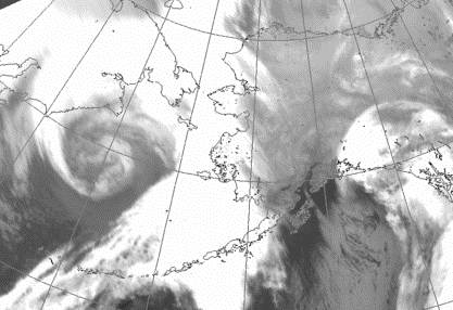
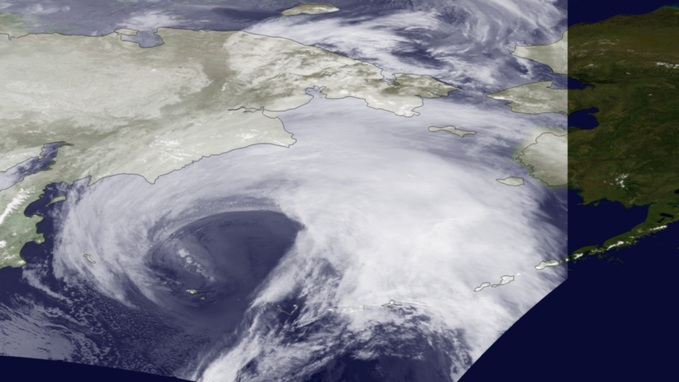
| Captured by the NOAA-19 satellite's AVHRR sensor, the storming bearing down on Alaska is seen in this infrared imagery on November 8, 2011 at 1400z. The storm is predicted to bring hurricane force winds and surge through the Bering Strait. Coastal flood warnings are in effect for much of western Alaska. Because of Alaska's high latitude, geostationary satellite do not provide adequate coverage. Polar-orbiting satellites like NOAA-19 are required to monitor severe weather in such areas. However, polar-orbiting satellites acquire imagery as swaths as the orbit around the planet. The area outside of the swath is visible in this image. | |
| Keywords: | Alaska, AVHRR, POES, 2011.11.08 |
| Size: | |
| Resolution: | 1920 x 1080 |
| Subject: | Environmental Science |
| Audience: |
Informal Education General Public |
| View NOAA Satellite Imagery of Bering Strait Storm - High Resolution Version | |
http://www.nnvl.noaa.gov/MediaDetail.php?MediaID=885&MediaTypeID=1
