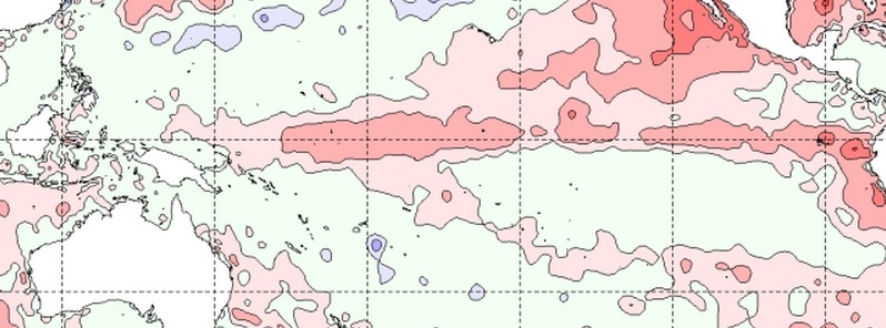
The El Niño in the tropical Pacific continues to strengthen, Australian Bureau of Meteorology (BOM) reports today. International climate models surveyed by BOM indicate sea surface temperatures will remain well above El Niño thresholds at least into the southern hemisphere spring.
Oceanic and atmospheric indictors show a clear El Niño signal. Sea surface temperatures in the tropical Pacific Ocean have exceeded El Niño thresholds for nearly two months, supported by warmer-than-average waters below the surface.
Trade winds have remained consistently weaker than average since the start of the year, cloudiness at the Date Line has increased, and the 90-day average Southern Oscillation Index (SOI) is now below –10.

| Index | Previous | Current |
Temperature change (2 weeks) |
|---|---|---|---|
| NINO3 | +1.2 | +1.3 | 0.1 °C warmer |
| NINO3.4 | +1.0 | +1.1 | 0.1 °C warmer |
| NINO4 | +1.1 | +1.1 | no change |
Baseline period 1961–1990. Credit: BOM.
The Indian Ocean Dipole (IOD) is currently neutral, with the majority of the Indian Ocean being warmer that average. Of the five international models that monitor the IOD, three suggest a positive IOD event is likely later in 2015.
Positive IOD events, often associated with lower rainfall in central and southeastern Australia, are more likely to occur during El Niño, the agency explains.
Temperatures in the Indian Ocean more broadly are warmer than average over much of the basin, with largest positive anomalies in the mid-latitudes of the southern hemisphere. However, since early May warm anomalies to the northwest of Australia and immediately to Australia’s west have largely dissipated. Temperature anomalies in the Indian Ocean have been a significant driver of Australia’s climate in recent months. As the El Niño unfolds, temperature patterns in the Indian Ocean will continue to have an influence on rainfall outlooks in the months ahead.
El Niño is often associated with below-average winter and spring rainfall over eastern Australia, and above-average daytime temperatures over the southern half of the country. However, the strength of El Niño doesn't directly relate to the strength of its effects on Australia's climate, BOM said.
Model outlooks
All eight of the surveyed international climate models indicate the central Pacific Ocean will warm further during the coming months. All surveyed models indicate that NINO3.4 will remain above El Niño thresholds through the southern hemisphere winter and at least well into spring.
There is some spread between model averages for the individual models surveyed, and greater spread between ensemble members within several of the individual models; this underscores that while substantial warming is expected, it is still too early to determine with confidence what the peak ocean temperatures for this El Niño will be. However, the consistency of model outlooks for further warming right through into the southern hemisphere spring, as opposed to some disagreement between models at this time last year, indicates a low likelihood of the current event breaking down rapidly.
Source: ENSO Wrap-Up issued by BOM on May 26, 2015.
Featured image: Monthly
http://thewatchers.adorraeli.com/2015/05/26/el-nino-tropical-pacific-continues-to-strengthen/?utm_source=feedburner&utm_medium=email&utm_campaign=Feed%3A+adorraeli%2FtsEq+%28The+Watchers+-+watching+the+world+evolve+and+transform%29
http://thewatchers.adorraeli.com/2015/05/26/el-nino-tropical-pacific-continues-to-strengthen/?utm_source=feedburner&utm_medium=email&utm_campaign=Feed%3A+adorraeli%2FtsEq+%28The+Watchers+-+watching+the+world+evolve+and+transform%29

