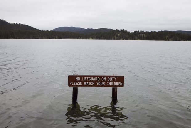
Throughout April, Ty Gerbracht, manager for forest recreation at the Pactola Reservoir, had been hoping to avoid a drought at Pactola Reservoir, so she prayed for rain.
She had no idea how effective those prayers would be.
"This is my payback," she said. "I prayed so hard for rain because I didn't want to start the camping season under a fire ban. I just didn't mean for it to rain this much."
After less than 3 inches of rain in April, which is the second lowest in state history, the weather completely reversed in May. About 9 inches of rain fell on Rapid City and the Black Hills last month, and it's a trend that has continued into early June.
The Pactola Reservoir has reached record high levels and several areas of the reservoir are now submerged, including sections of the Veteran's Point trail, many places in the parking lot, the Pactola Pines Marina building and the beach grounds, not to mention the countless logs and trees that were knocked over in the October 2013 blizzard.
The reservoir is considered full at 4,580.2 feet above sea level, according to the Bureau of Reclamation. The reservoir is now 4,587.2 feet above sea level, which breaks the record of 4,585.87 that had been set in 1965.
Both the southern and northern boat ramps have been blocked off and closed after members of the Black Hills National Forest Service expressed concerns that it was unsafe for people to launch their boats from either dock.
"The water is so far up that there is no angle on the ramp," said Mina Showman, Recreation and Lands Staff for the Mystic Ranger District. "It would be very difficult for people to get their boats in the water and, just as importantly, get them back onto the shore."
The beaches have also been closed down because so much of the area is underwater. About nine of the picnic tables and the nearby grills were submerged Thursday afternoon. It was difficult to even see the tables from a boat or dry land.
"I can't open the beach because I'm afraid that children that would be playing in the water might accidentally run into an underwater hazard," Gerbracht said.
However, just because the boat launches and beaches are unusable doesn't mean the entire reservoir is closed, she said.
The Pactola Lake Campground is well above the shoreline and perfectly suitable for campers. And, despite the flooding of the marina building, the actual marina still has plenty of boats available for rent.
Dave Fisher, owner of Pactola Pines Marina, said he thinks many people assume that the entire reservoir is closed because the two boat launches are off limits.
"As far as marina operations go, we are staying open. The campground is open, we are moving docks around as water comes up so the marina can have access to the shoreline," Fisher said.
The reservoir was practically deserted Thursday afternoon, although it was hard to tell if the lack of visitors was because people thought it was closed or if it was because of the unseasonably cold weather.
In either case, Fisher said he believes that once the weather gets warmer and more people are aware that the park is still available for recreational purposes, things will pick back up.
"I think once the docks are re-opened and the weather changes, the crowds will return," he said.
Rapid City is currently releasing 500 cubic feet of water per second through the river outlet works at Pactola Dam to alleviate the flooding, according to a news release from the Bureau of Reclamation.
Ginger Wessels, spokeswoman for the Bureau of Reclamation, said the bureau does not believe that the backed-off release at Pactola for the Canyon Lake dredging project a few months ago had any impact on the flooding that Pactola is now experiencing.
"Our normal target is to have the reservoir full by May 1," she wrote in an email. "We were actually over a foot below our target elevation on May 1. Since then, we've had over 8 inches of rain in May, plus what we have received in June."
Other reservoirs in the Black Hills have also had higher water levels than usual, according to the Bureau of Reclamation.
Angostura Irrigation District continues to release water through the spillway and canal system into the Cheyenne River, with the current release at approximately 700 cfs. Future releases will depend on inflows. The current water elevation at Angostura Reservoir is 3,185.1 feet, which is 92 percent full. Angostura Reservoir is full at an elevation of 3,187.2 feet.
Rapid City continues to release approximately 70 cubic feet of water per second from Deerfield Reservoir into Castle Creek. The releases could be maintained through the rest of June. The water elevation at Deerfield Reservoir is at 5,907.95 feet, with full capacity at 5,908 feet.

(Click on photos to view slide show)
The Belle Fourche Reservoir is 96 percent full with an elevation at 2,974.1 feet. Full reservoir elevation is 2,975 feet. The current release is approximately 155 cubic feet of water per second through the North and South Canals.
Shadehill Reservoir is 90 percent full with an elevation at 2,269.55 feet. Full reservoir elevation is 2,272 feet. Releases through the outlet works have been set at approximately 50 cubic feet of water per second. All numbers are from Thursday evening.
