Israeli Army Orders Confication of Palestinian Land in West Bank
Conal Urquhart in Jerusalem
Posted Feb. 7, 2009
(Written Wednesday 10 October 2007)
· Seizure would allow huge expansion of settlements · Move seen as rush to make changes before US summit

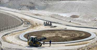
Construction workers in the West Bank. Photograph: Sebastian Scheiner/AP
The Israeli army has ordered the seizure of Palestinian land surrounding four West Bank villages apparently in order to hugely expand settlements around Jerusalem, it emerged yesterday.
The confiscation happened as Israeli and Palestinian negotiators met to prepare the ground for a meeting hosted by President George Bush in the United States aimed at reviving a diplomatic solution to the conflict.
However, critics said the confiscation of land suggested that Israel was imposing its own solution on the Palestinians through building roads, barriers and settlements that would render a Palestinian state unviable.
The land seized forms a corridor from East Jerusalem to Jericho and is intended to be used for a road that would be for Palestinians only. Analysts said the road would run on one side of the Israeli security barrier, while the existing Jerusalem-Jericho road would be reserved for Israelis.
A spokeswoman for the Israeli army said it was necessary to build a road to link Bethlehem and the Judea region with Jericho and the Jordan valley area in order to "improve the quality of life" for Palestinians.
She said the road would be nearly 10 miles long and would be built on 145 hectares (357 acres) of state land and 23 hectares of private land that had been confiscated. She added that the army had designed the route to minimise losses to private landowners.
Adam Keller of the Israeli peace group, Gush Shalom, said the confiscation of land belonging to the villages of Abu Dis, Arab al-Sawahra, Nebi Musa and Talhin Alhamar would "rob many villagers of their sole livelihood" but would also "facilitate the big annexation plan known as E-1, which is aimed at linking the settlement of Ma'aleh Adummim with Jerusalem and cutting the West Bank in two."
He said the confiscations were aimed at constructing a "Palestinian bypass road" that would "push the Palestinian traffic between Bethlehem and Ramallah deep into the desert and effectively bar them from the central part of the West Bank".
The E-1 area has been marked out on Israeli government maps for years but the state has refrained from large scale development of the area. The only building to be completed is the proposed headquarters of the Israeli police in the West Bank.
The plan for the area envisages 3,500 housing units and dozens of businesses which have yet to be started, although infrastructure such as roads and drainage is being constructed.
Jeff Halper, an Israeli geographer who specialises in Israel's development of the West Bank, said it appeared that there was a rush to carry out as much work as possible before the US-sponsored meeting between Mahmoud Abbas, the Palestinian president, and Ehud Olmert, the Israeli prime minister, in Annapolis, Maryland, in November.
"They want to push everything as far as possible before the November meeting because that will be seen as the starting point for everything," he said. "Anything done before that meeting will be set in stone. In general this has to be seen as part of a timeline in which Israel wants to get all its development of the West Bank finished before Bush leaves office."
The land confiscation orders emerged as Palestinian officials claimed that a revised route of the West Bank barrier would eat into substantially more Palestinian land than the previous route.
The negotiation affairs department of the Palestine Liberation Organisation said information released by the Israeli ministry of defence showed that the new route would annex 12% of the West Bank, compared with 9% previously.
The biggest change in the route of the barrier is in the south-east of the West Bank, adjacent to the coastline of the Dead Sea. The area is mostly uninhabited but could be useful for industry or tourism in the future.
The new route also adds in two settlements, Nili and Na'aleh, which would result in five villages close to Ramallah being almost totally surrounded by the barrier, the PLO statement said.
Israel says that the security barrier, which is in parts a high concrete wall and in other parts a steel fence with wide ditches, is vital for ensuring security in Israel.
However, the PLO statement said that the main aim of the barrier was "to consolidate Israeli control over the most critical parts of the occupied West Bank, including all of Palestinian East Jerusalem and vital land and water resources, all of which severely undercuts prospects for establishing a viable, independent Palestinian state."
www.guardian.co.uk/world/2007/oct/10/israel/print
